Prove Your School Street Works. Make It Permanent.
The data-led toolkit for Australian and New Zealand councils running School Streets trials, from baseline to permanence.
Every School Street trial faces the same challenge: community support is high, but the evidence base is thin. Without continuous, objective data, councils cannot prove that traffic has genuinely reduced, that active travel has increased, or that the intervention is safe enough to make permanent.
The VivaCity School Streets Starter Kit gives Active Travel and Road Safety teams the methodology, case studies, and framework mapping needed to build an undeniable case — from the first sensor installation to the final council report.

Why VivaCity?
260
authorities
globally empowered by VivaCity solutions
20+
cities
across ANZ using VivaCity data & insights
6,000+
sensors
deployed across 12 countries
35 billion+
counts
of unique road users recorded
Why Most School Streets Trials Stall
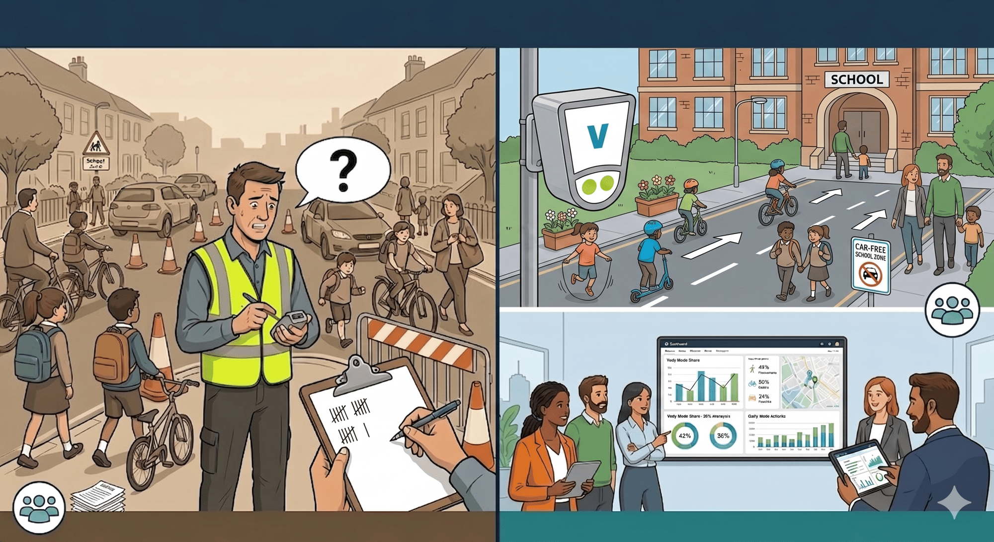
The barriers to making a School Street permanent are rarely political — they are evidential. When a council cannot demonstrate with objective, continuous data that the intervention has reduced traffic, improved safety, and increased active travel, the case for permanence weakens under scrutiny.
Manual counts are expensive, infrequent, and unable to capture the full picture. They miss the "afterglow" effect — the way a timed closure can change driver behaviour throughout the entire day, not just during restriction hours. They cannot detect near-miss conflicts outside the school gate. And they cannot prove that traffic has evaporated rather than simply moved to the next street.
Continuous, multimodal monitoring changes this. It gives councils the objective, 24/7 evidence needed to answer every question a sceptic can raise.
What You Will Find in the Starter Kit
The kit is a practical, professional guide written for council Active Travel, Road Safety, and Transport teams. It covers every stage of a School Streets programme — from scoping to permanence.

Data Fundamentals Heading:
Understanding the Five Core Data Types
Before you can evaluate a School Street, you need to know what to measure. The guide explains the five fundamental data types — multimodal counts, classified speeds, path trajectories, near-miss detection, and dwell time — and why each one is essential to a complete evaluation.

Sensor Installation Heading:
Strategic Sensor Placement: A Step-by-Step Guide
Where you place your sensors determines the quality of your evidence. The guide provides a detailed street schematic showing the optimal positions for compliance sensors, active travel sensors, and displacement sensors — plus practical guidance on mounting heights, power options, and occlusion checks.

Framework Mapping Heading:
Mapped Against the Frameworks That Matter to ANZ Councils
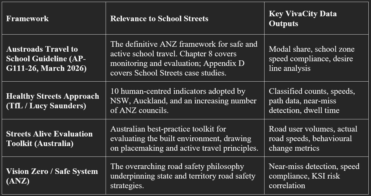
The guide maps every VivaCity data output against the four frameworks most relevant to Australian and New Zealand councils: the Austroads Travel to School Guideline (AP-G111-26), the Healthy Streets Approach, the Streets Alive Evaluation Toolkit, and the Vision Zero / Safe System. You will know exactly which data to collect, and exactly how to report it.

Evidence and Reporting Heading:
Real-World Evidence: How to Build the Case for Permanence
The guide includes deep dives into the Westminster City Council School Streets trial and the University of Westminster's Hackney research — with specific data on traffic reduction, cycling uplift, and compliance rates. It explains how to structure a post-trial report that moves decision-makers from "let's extend the trial" to "let's make it permanent."
How Councils Are Using VivaCity Data
Westminster City Council, UK
11 School Streets Made Permanent. One Data Platform Made It Happen.

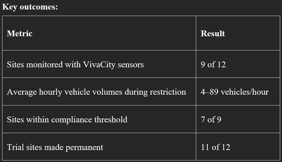
Westminster City Council launched temporary School Streets trials at 12 locations in January 2022 as part of its Fairer Westminster Strategy. VivaCity sensors were installed at nine of the twelve sites, providing continuous 24/7 monitoring throughout the trial period.
The data told a clear story. Average hourly motorised vehicle counts during restriction windows remained extremely low — ranging between just 4 and 89 vehicles per hour across the monitored sites. Only two of the nine sites recorded volumes above the strict compliance threshold. Pedestrian path data showed strong use of the footway, with some carriageway use indicating that students and parents felt comfortable in the space.
When the council reviewed the trial in March 2023, the combination of VivaCity sensor data and community questionnaire responses provided an objective, defensible evidence base. The council announced that 11 of the 12 trial sites would be made permanent, with a commitment to install further School Streets over the following three financial years.
"VivaCity data has played an important role in the evaluation of the School Streets trial. The data has helped to substantiate and give context in conjunction with the online School Streets feedback questionnaire responses, along with informing the decision-making process as to which trial sites were to be made permanent."
— Carla Leowe, Road Safety Officer, Westminster City Council
Hackney / University of Westminster Active Travel Academy, UK
The Data That Proved School Streets Change Behaviour All Day Long in Hackney, London.

When the University of Westminster's Active Travel Academy set out to evaluate two School Streets in Hackney, they used VivaCity sensor data to go beyond simple compliance counts. The research, published in collaboration with VivaCity, revealed findings that have since shaped best practice for School Streets evaluation globally.
The most significant discovery was the "afterglow" effect. The decrease in motorised traffic did not simply occur during the restriction window — it persisted throughout the entire day. This suggests that timed closures can fundamentally change driver routing habits over time, delivering benefits that extend far beyond the morning and afternoon peaks.
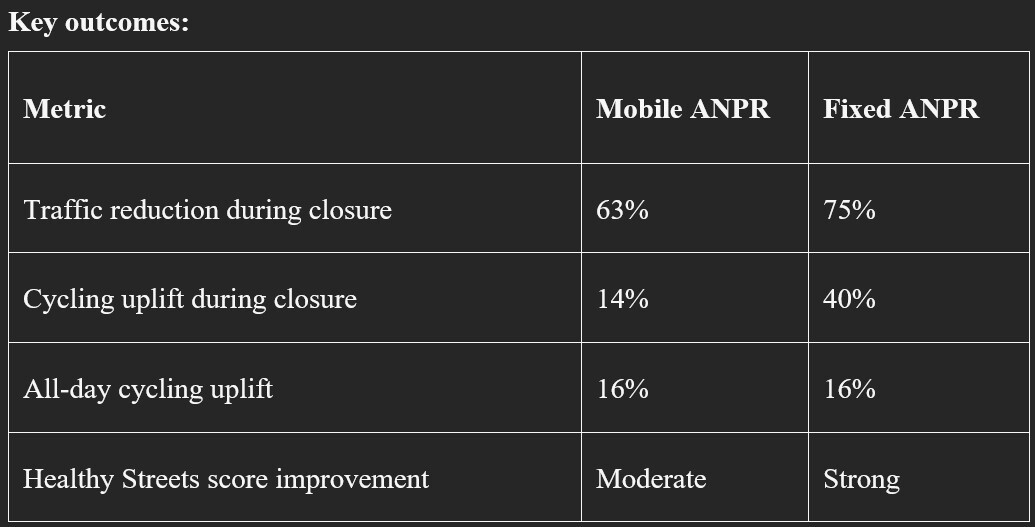
The research also provided the most rigorous comparison of enforcement methods available in the literature. Fixed ANPR enforcement produced a 75% decline in traffic at Fairholt Road, compared to a 63% decline with mobile ANPR. The cycling uplift was equally striking: a 40% increase in cyclists during closure times under fixed ANPR, compared to a 14% increase with mobile ANPR, and a 16% general increase throughout the day.
Healthy Streets scores improved measurably across both sites, with the biggest gains in the "clean air" and "not too noisy" indicators. Path data revealed that pedestrian carriageway use rose from 3.8% before implementation to 4.2% with full ANPR at Fairholt Road, and to 16% at Rendlesham Road — a clear signal that students and families were beginning to reclaim the street.
"These findings also show how helpful continuous monitoring can be in assessing the impacts of temporary closures, not just when they're in place, but also over the course of days, weeks and months."
—Asa Thomas, PhD Researcher, Active Travel Academy, University of Westminster
Hobart City Council, Tasmania
Neutral Data Wins Political Arguments.

When Hobart City Council introduced new cycle lanes in the CBD, the scheme became politically contentious. Opponents argued that the lanes were reducing footfall for local businesses and creating congestion. The council needed objective, continuous data to either confirm or refute these claims — and to make the case for transitioning the trial infrastructure to permanent.
VivaCity sensors were installed on signal columns throughout the CBD, simplifying power requirements and enabling data sharing between city and state stakeholders. The resulting data provided the neutral, evidence-based foundation the council needed. The sensor network showed that cycle lanes had increased the number of passers-by, not reduced them, and the data supported the transition from a temporary trial to permanent infrastructure.
The Hobart deployment also demonstrated a key operational advantage of the VivaCity platform in the ANZ context: the ability to install sensors on existing signal column infrastructure, enabling rapid deployment without civil works and facilitating data sharing across council and state agency boundaries.
The kit is free. It is written for council professionals — Active Travel Coordinators, Road Safety Officers, Transport Planners, and Infrastructure Managers — who want a practical, evidence-based guide to planning, monitoring, and evaluating School Streets programmes.
What you will receive: A comprehensive professional guide covering the five fundamental data types, strategic sensor installation schematics, a step-by-step evaluation methodology, a full framework mapping matrix, and real-world case studies from VivaCity programmes.

Trusted by councils and transport authorities across Australia, New Zealand, and globally.